Places to Visit in Utsjoki
The municipality of Utsjoki is Finland’s northernmost and also the only one where the Sámi population has the majority. A visit can take place year-round. Utsjoki presents the possibility to explore modern, daily life Sámi culture.
Route 970
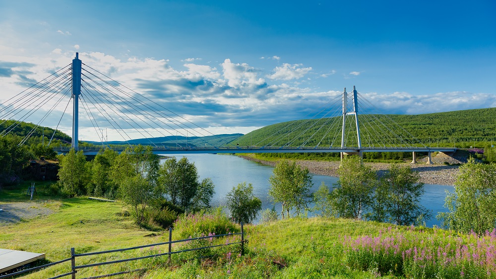
For 100 km, route 970 takes you from Karigasniemi to Utsjoki, passing the River Teno and continue to Nuorgam. The road is rewarded as most beautiful route in Finland due the view on the beautiful river and a breathtaking river valley.
Ailigas fells
In Utsjoki, you can find three fells called Ailigas, located near the River Tenojoki. The highest of 620m reveals in Karigasniemi, where River Inarijoki becomes River Tenojoki. The second highest, Nuvvus-Ailigas, with 535m, can be found at the shore of the Tenojoki River located in Nuvvus village. The smallest one is 342m high and protects the centre of Utsjoki village.
River Tenojoki
One of the best and largest salmon river of Europe is the River Tenojoki. Around the 19th century, the river was discoverd by a fly-fishing fan and was the beginning of recreational fishing tourism. It is located at the border of Finland and Norway, and for that reason considered as the northern border of European Union. It consists of a river valley where you can find sandy beaches and rugged fells.
Parish huts and Utsjoki Church
14 huts are still remained in the parish village, built in the 18th and 19th centuries. It was home to the Sámi families. The location is 6km away from the Utsjoki village, on the shores of Lake Mantojärvi. It is part of cultural historical sites in the region. In 1853, the stone church was developed on the commission of Nicholas I of Russia.
Kevo Strict Nature Reserve
The landscape of Lapland is at its most beautiful in the Kevo Strict Nature Reserve. Hikers can explore the region by following one of two defined paths, 63km and 86,5km. Both trails are fairly demanding.
Karigasniemi & Kaamanen
Kaamanen is a village located 40 kilometers north of Inari. Kaamanen is a typical meeting point from which you can travel north, east, south, or west on a road or through a snowmobile groove. The fishing and wilderness cultures are strong in Kaamanen. Trout and grayling can be found in the River Kaamasjoki and other nearby fishing lakes. The area, which is teeming with forest fowl, is also well-known among birdwatchers around the world, and it is particularly praised as a bird photographer’s paradise. Many Arctic bird species can be seen in Kaamanen in association with feeding areas, and sighting them elsewhere is a matter of luck.
Karigasniemi is a meeting place for the Sámi, Finnish and Norwegian languages and cultures. Karigasniemi is located on the Finnish-Norwegian border in the municipality of Utsjoki. The River Inari, which turns into the River Teno at the confluence of the River Kaarasjoki a few kilometers north of Karigasniemi, runs along the village’s border. The rivers provide excellent chances for activities such as camping and fly fishing. You may easily go to the Arctic Ocean from Karigasniemi, as far as Porsang Fjord or Nordkapp.
Sulaoja spring
A sacred place for Sámi culture is Sulaoja, also known as the biggest natural spring in Finland. Sámi people say that the water has a healing character. The place gives you acces to the Southern starting point of Kevo Strict Nature Reserve, where you can easily walk a 2 km nature trail to the Sulaoja spring.
Muotkatunturi Wilderness Area
Muotkantunturi Wilderness Area is the place for hikers who are experienced, since there are no marked trails and only a few huts to stay overnight. It is known for his distinctive appearance with the Lake Peltojärvi, rivers and the rolling fells.
Paistunturi Wilderness Area
In the middle of Kaamanen, Karigasniemi and Utsjoki, you can find the Wilderness Area of Paistunturi. In the area, you find fell tops of 600 metres high with vast mires, mountain birch forests and fell heaths.
Lappish gold
Lemmenjoki keeps up a history of gold panning. Today, gold-diggers are still active, and also visitors can have the adventure of panning gold in the guided tours. You can combine it with a visit to Ravadas waterfalls or Joenkielinen fell.
Lemmenjoki National Park
The National Park is known as the largest national park in Finland. But Lemmenjoki National Park is also one of the largest uninhabited wilderness areas that Europe has to offer. The name comes from the Sámi word Lemmee. The local lifestyle of the Sámi people is still visible, and you can join a guided tour organised by local Sámi entrepreneurs.
River Lemmenjoki flows 70 km long trough the park. The park gives multiple options to go hiking on the maintained trails, or stay for a lunchbreak in the wilderness hunts and sleep overnight in a rental cabin where you have the opportunity to make a campfire.
Joenkielinen Fell
Looking for a day trip activity? The fell of Joenkielinen gives you a splendid view on the river valley of Lemmenjoki and surroundings. You get to the top following a trail, that takes you next to the river valley.
Ravadas waterfalls
The Ravadas waterfalls, also known as Ravadasköngäs in Finnish, is one of the popular sights in the National Park of Lemmenjoki. If you are hiking, you can follow the marked trails and watch the waterfall closely, or join a riverboat ride. Closeby, you can find a wilderness hut.
Näätämö & Sevettijärvi
In terms of demographic and cultural preservation, Sevettijärvi is the epicenter of Finnish Skolt culture. Lake Sevettijärvi is located in Norway, on the road between Näätämö and Kirkenes. Skolt Sámi were evacuated from Petsamo after the conflicts and settled there, bringing their culture with them. The only site where the Skolt Sámi language is still spoken is at Lake Sevettijärvi.
The settlement of Näätämö is located 30 kilometers from Lake Sevettijärvi and only 12 kilometers from the Arctic Ocean. The Näätämöjoki River, which flows into the Arctic Ocean and is where salmon and trout are harvested. Norway and Näätämö have a thriving border trade.
Skolt Sámi Traditions
Sevettijärvi is a village in municipality Inari, located in the northern-eastern corner of Finnish Lapland. Näätämö is half-an-hour away and is located at the border. It is a famous place for fishing, since the River Näätämöjoki is so close.
It is a unique place, since this is one of the only places where they still daily speak the Skolt Sámi language. The population itself is the indigenous population from the Kola Peninsula in Russia. In the Second World War, they lost their native lands in Petsamo. The traditional clothing style, festival traditions, food traditions and music is still kept alive in Sevettijärvi.
Sevetti-Pulmanki Trail
A 70 km long hiking trail that takes you through the Kaldoaivi wilderness. It is recommended to go hiking from July until August, with some wilderness huts on the trail. In wintertime, there are winter trails for snowmobilers and skiers. The birch trees are the biggest part of the vegetation and leads from Lake Pulmankijärvi.
Vätsäri Wilderness Area
Close to the borders of Norway and Russia, you will find Vätsäri Wilderness Area. It is a recommended place for experienced hikers and is located behind Inarijärvi. The Wilderness Area is part of Pasvik-Inari Trilateral Park, a protected district.
River Näätämöjoki
On the north of Sevettijärvi, river Näätämöjoki is an amazing opportunity for fly fishing. Fishes such as salmon, grayling, whitefish and trout are in the waters. If you would like to try fishing in the roaring river, you can be guided by a professional fisherman.
Skolt Sámi Heritage House & Orthodox Church
The perfect place to gain knowledge about Skolt Sámi people is by paying a visit to Skolt Sámi Heritage House. It is free of charge and can be visited in summertime. It can be combined with a visit to Orthodox Church, right next to the Heritage House.
Nuorgam – EU’s most northern village
Nuorgam, Finland’s and the EU’s northernmost village, is a happy place. Tourism and border trade support almost 200 people in the town. Tourists are drawn to the area because of the possibility of catching large salmon. In Nuorgam, happiness can be found in the beauty of nature and unbroken serenity, in addition to pleasant people. Tourists can visit Nuorgam to experience Finland’s longest nightmare and nightless night. In the time between 16.5 and 29.7, the sun does not set at all.
Nuorgam has good opportunities for day trips to Norway and the shores of the Arctic Ocean. In addition to fishing, Nuorgam organizes canoe trips, hiking, mountain bike tours and, in winter, hiking to the fells and other winter activities.
Pulmankijärvi Lake
20 kilometeres in south direction of Nuorgam, you will find Pulmankijärvi Lake. It is a perfect place for bird watching or to see the gyrfalcon nesting on the fell side.
River Tenojoki
The village is located next to the Teno river and is well-known for salmon fishing. This is one of the best activities you can do during summer in Nuorgam’s quiet waters. It is possible to do it from 10th June – 10th August. You will need a fishing licence to fish salmon. You can also rent a boat, a guide or the necessary fishing equipment from Nuorgam Holiday Village.
Kaldoaivi Wilderness Area
Kaldoaivi is known as the largest wilderness area in Finland. The variation goes from fell tops to steep river valleys. The area continues also on the Norwegian side. You can explore just for one day or also suitable for several day trips. If you are a beginner hiking, it is recommended to go with a more experienced hiker.
Sevetti-Pulanki Trail
A trail of 60-70 km, that takes you to the eastern part of the Kaldoaivi Area. The Pulmankijärvi Lake (Utsjoki) is the end of the trail on the northern end. The Skolt Sámi Heritage House is the end of the trail on the southern side.
Southern trail: takes you along the pine forests.
Northern trail: fell highlands and treeless mires.
Landmark northernmost tip
Visit the landmark of the northernmost tip of Finland and EU. It is located when you cross the road 970, close to Nuorgam village. 30 kilometres further is the Arctic Ocean located.